| Oracle7 Spatial Data Option User's Guide and Reference | Library |
Product |
Contents |
Index |
| Oracle7 Spatial Data Option User's Guide and Reference | Library |
Product |
Contents |
Index |
![]()
![]()
This chapter describes how to load spatial data into a database, including storing the data in a table and creating a spatial index for it.
2.1 Load Model
There are two steps involved in loading raw data into a spatial database such that it can be queried efficiently:
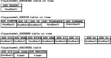
Figure 2¯1 Geometry Layer Tables
2.2 Loading Process
The process of loading data can be classified into two categories:
Assume that the raw data consists of a file with delimited (non-fixed) columns, and separate table-delimited rows with the following format:
geometry rows: GID, ESEQ, ETYPE, SEQ, LON1, LAT1, LON2, LAT2
The following shows the control file for loading the data into the geometry table:
LOAD DATA INFILE *
REPLACE
INTO TABLE ROADS_SDOGEOM
FIELDS TERMINATED BY WHITESPACE TRAILING NULLCOLS
(SDO_GID INTEGER EXTERNAL,
SDO_ESEQ INTEGER EXTERNAL,
SDO_SEQ INTEGER EXTERNAL,
SDO_X1 FLOAT EXTERNAL,
SDO_Y1 FLOAT EXTERNAL,
SDO_X2 FLOAT EXTERNAL,
SDO_Y2 FLOAT EXTERNAL)
BEGINDATA
1 0 3 0 -122.401200 37.805200 -122.401900 37.805200
1 0 3 1 -122.401900 37.805200 -122.402400 37.805500
1 0 3 2 -122.402400 37.805500 -122.403100 37.806000
1 0 3 3 -122.403100 37.806000 -122.404400 37.806800
1 0 3 4 -122.404400 37.806800 -122.401200 37.805200
1 1 3 0 -122.405900 37.806600 -122.407549 37.806394
1 1 3 1 -122.407549 37.806394 -122.408300 37.806300
1 1 3 2 -122.408300 37.806300 -122.409100 37.806200
1 1 3 3 -122.409100 37.806200 -122.405900 37.806600
2 0 2 0 -122.410800 37.806000 -122.412300 37.805800
2 0 2 1 -122.412300 37.805800 -122.414100 37.805600
2 0 2 2 -122.414100 37.805600 -122.412300 37.805800
2 0 2 3 -122.412300 37.805800 -122.410800 37.806000
3 0 1 0 -122.567474 38.643564
3 0 1 1 -126.345345 39.345345Note that tables ROADS_SDOGEOM need to exist in the schema before attempting the load.
SDO_GID SDO_ESEQ SDO_ETYPE SDO_SEQ SDO_X1 SDO_Y1 SDO_X2 SDO_Y2The corresponding control file for this format of input data would be:
LOAD DATA INFILE *
REPLACE
INTO TABLE NEW_SDOGEOM
(SDO_GID POSITION (1:5) INTEGER EXTERNAL,
SDO_ESEQ POSITION (7:10) INTEGER EXTERNAL,
SDO_ETYPE POSITION (12:15) INTEGER EXTERNAL,
SDO_SEQ POSITION (17:21) INTEGER EXTERNAL,
SDO_X1 POSITION (23:35) FLOAT EXTERNAL,
SDO_Y1 POSITION (37:48) FLOAT EXTERNAL,
SDO_X2 POSITION (50:62) FLOAT EXTERNAL,
SDO_Y2 POSITION (64:75) FLOAT EXTERNAL)
BEGINDATA
1 0 3 0 -122.401200 37.805200 -122.401900 37.805200
1 0 3 1 -122.401900 37.805200 -122.402400 37.805500
1 0 3 2 -122.402400 37.805500 -122.403100 37.806000
1 0 3 3 -122.403100 37.806000 -122.404400 37.806800
1 0 3 4 -122.404400 37.806800 -122.401200 37.805200
1 1 3 0 -122.405900 37.806600 -122.407549 37.806394
1 1 3 1 -122.407549 37.806394 -122.408300 37.806300
1 1 3 2 -122.408300 37.806300 -122.409100 37.806200
1 1 3 3 -122.409100 37.806200 -122.405900 37.806600
2 0 2 0 -122.410800 37.806000 -122.412300 37.805800
2 0 2 1 -122.412300 37.805800 -122.414100 37.805600
2 0 2 2 -122.414100 37.805600 -122.412300 37.805800
2 0 2 3 -122.412300 37.805800 -122.410800 37.806000
3 0 1 0 -122.567474 38.643564
3 0 1 1 -126.345345 39.345345
INSERT INTO SAMPLE_SDOGEOM (SDO_GID, SDO_ESEQ, SDO_ETYPE, SDO_SEQ,
SDO_X1, SDO_Y1, SDO_X2, SDO_Y2, SDO_X3,
SDO_Y3, SDO_X4, SDO_Y4, SDO_X5, SDO_Y5)
VALUES (17, 0, 3, 0, 5, 20, 5, 30, 10, 30, 10, 20, 5, 20);
-- hole
INSERT INTO SAMPLE_SDOGEOM (SDO_GID, SDO_ESEQ, SDO_ETYPE, SDO_SEQ,
SDO_X1, SDO_Y1, SDO_X2, SDO_Y2, SDO_X3,
SDO_Y3, SDO_X4, SDO_Y4, SDO_X5, SDO_Y5)
VALUES (17, 1, 3, 0, 8, 21, 8, 24, 9, 24, 9, 21, 8, 21);
-- point
INSERT INTO SAMPLE_SDOGEOM (SDO_GID, SDO_ESEQ, SDO_ETYPE, SDO_SEQ,
SDO_X1, SDO_Y1)
VALUES (17, 6, 1, 0, 9, 29);
The SQL INSERT statement inserts one row of data per call. In the previous example, the table had enough columns to store the polygon in a single row. However, if your table had fewer columns (or your polygon had more points), you would have to break the insert into multiple lines to match the table structure. Repeat the SDO_GID, SDO_ESEQ, and SDO_ETYPE, and increment the SDO_SEQ for each line as follows:
INSERT INTO SAMPLE2_SDOGEOM (SDO_GID, SDO_ESEQ, SDO_ETYPE, SDO_SEQ,
SDO_X1, SDO_Y1, SDO_X2, SDO_Y2, SDO_X3,
SDO_Y3, SDO_X4, SDO_Y4, SDO_X5, SDO_Y5)
VALUES (18, 0, 3, 0, 1, 15, 1, 16, 2, 17, 3, 17, 4, 18);
INSERT INTO SAMPLE2_SDOGEOM (SDO_GID, SDO_ESEQ, SDO_ETYPE, SDO_SEQ,
SDO_X1, SDO_Y1, SDO_X2, SDO_Y2, SDO_X3,
SDO_Y3, SDO_X4, SDO_Y4, SDO_X5, SDO_Y5)
VALUES (18, 0, 3, 1, 4, 18, 5, 18, 6, 19, 7, 18, 6, 17);
INSERT INTO SAMPLE2_SDOGEOM (SDO_GID, SDO_ESEQ, SDO_ETYPE, SDO_SEQ,
SDO_X1, SDO_Y1, SDO_X2, SDO_Y2, SDO_X3,
SDO_Y3, SDO_X4, SDO_Y4, SDO_X5, SDO_Y5)
VALUES (18, 0, 3, 2, 6, 17, 7, 16, 7, 15, 6, 14, 7, 13);
INSERT INTO SAMPLE2_SDOGEOM (SDO_GID, SDO_ESEQ, SDO_ETYPE, SDO_SEQ,
SDO_X1, SDO_Y1, SDO_X2, SDO_Y2, SDO_X3,
SDO_Y3, SDO_X4, SDO_Y4, SDO_X5, SDO_Y5)
VALUES (18, 0, 3, 3, 7, 13, 6, 12, 5, 13, 4, 13, 3, 14);
INSERT INTO SAMPLE2_SDOGEOM (SDO_GID, SDO_ESEQ, SDO_ETYPE, SDO_SEQ,
SDO_X1, SDO_Y1, SDO_X2, SDO_Y2, SDO_X3, SDO_Y3)
VALUES (18, 0, 3, 4, 3, 14, 2, 14, 1, 15);
There are two steps to incrementally add data to the spatial tables:
elem_value := sdo_geom.init_element('ROADS', 1234);
Next, call SDO_GEOM.ADD_NODES() to fill in the attributes of the polygon. The vertices can be added in either clockwise or counter-clockwise order.
sdo_geom.add_nodes('ROADS', 1234, elem_value, sdogeom.polygon_type, Ax, Ay, Bx, By, Cx, Cy, Dx, Dy, Ex, Ey, Ax, Ay));
Close the polygon by repeating the first vertex (Ax,Ay) as the last vertex.
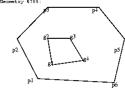 Polygon With a Hole
val1 := sdo_geom.init_element('PARKS', 6789);
sdo_geom.add_nodes('PARKS', 6789, val1, SDO_GEOM.POLYGON_TYPE, p1x, p1y, p2x, p2y,, p3x, p3y, p4x, p4y, p5x, p5y, p6x, p6y, p1x, p1y);
val2 := sdo_geom.init_element('PARKS', 6789);
sdo_geom.add_nodes('PARKS', 6789, val2, g1x, g1y, g2x, g2y, g3x, g3y , g4x, g4y, g1x, g1y);
Create a table called <layername>_SDOINDEX with the following structure:
(SDO_GID integer, SDO_CODE raw(254))
For a bulk load, you can call the SDO_ADMIN.POPULATE_INDEX_FIXED() procedure once to tessellate the geometry table and add the generated tiles to the spatial index table. The arguments to this procedure are the name of the layer, a factor for creating fixed-size tiles that the geometry should be tessellated into, and a flag to determine if the entire geometry table should be tessellated or just the objects that do not have corresponding entries in the spatial index table. See Chapter 5, "Administrative Procedures" for a complete description of the SDO_ADMIN.POPULATE_INDEX_FIXED() procedure.
If data is updated in or deleted from a specific geometry table, you can call SDO_ADMIN.UPDATE_INDEX_FIXED() to update the index for the designated GID. The arguments to this procedure are the name of the layer, the GID of the designated geometry, the size of tiles the geometry should be tessellated into, and a replace flag. The replace flag signals whether or not to delete any existing tiles for the geometry prior to tessellating.
2.3.1 Indexing With Fixed-Size Tiles
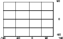
Spatial Data Option uses two different tessellation schemes for creating cover tiles for a geometry. Most of the examples in this manual describe indexing with fixed-size tiles because that is generally the most efficient for most cases. However, in some cases an application might call for variable-size tiles. Tessellating the geometry into fixed-size tiles might have benefits related to the type of data being stored, such as using tiles sized to represent one-acre farm plots, city blocks, or individual pixels on a display.Figure 2¯3 Fixed-Size Tiling
To generate fixed-size tiles, use the SDO_ADMIN.POPULATE_INDEX_FIXED() procedure and pass it the number of times the layer should be tessellated. For example, setting the tile_size parameter to 1 would specify one subdivision. Each tile would be 180 degrees by 90 degrees as shown in Figure 2-4: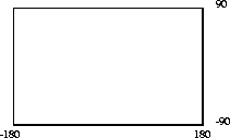
Figure 2¯4 Fixed-Size Tiling at Level 1
The formula for the number of fixed-size tiles is 4n where n is the tile_size parameter passed to the SDO_ADMIN.POPULATE_INDEX_FIXED() procedure. Figure 2-5 shows fixed-size tiling at level 2. In this example, each tile is 90 degrees by 45 degrees.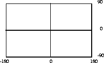
Figure 2¯5 Fixed-Size Tiling at Level 2
Example 2¯6
sdo_admin.populate_index_fixed('ROADS', 10, false, false, false);
The number 10 in the parameter list specifies the level of tiles an object must be tessellated into. This parameter can be used as a tuning parameter while tessellating objects. Increasing the level increases the number of tiles to provide a more precise fit of the tiles over the object.After SDO_ADMIN.POPULATE_INDEX_FIXED() has been called to fill the spatial index, you should also create standard indexes on the <layername>SDOINDEX.CODE column.
If a geometry with a GID 5944 has been added to the spatial tables, update the index with the following procedure:
sdo_admin.update_index_fixed('ROADS', 5944, 10, FALSE, FALSE, FALSE);
If a large number of geometries have been added to the database, the SDO_ADMIN.POPULATE_INDEX_FIXED() procedure should be used instead of the SDO_ADMIN.UPDATE_INDEX_FIXED() procedure. This is often a simpler alternative because it does not require you to specify each SDO_GID for which the index should be updated. It reads the tables and automatically creates index entries as needed.
|
Prev Next |
Copyright © 1996 Oracle Corporation. All Rights Reserved. |
Library |
Product |
Contents |
Index |