DESCRIPTION OF THE 1d SOLAR EVENT MAP
Map of the solar events shows projections of different phenomena and events
on the solar surface in the rectangular helio-coordinates.
The shown solar events were observed in a time interval around a
given time. In the case of 1d Map this is 1 day interval around the moment of the
solar wind stream start from the Sun. This moment is restored using
maximal velocity observed within 12 hours before observed maximal
Ap-index value during the geomagnetic disturbed day
(see description of time profiles).
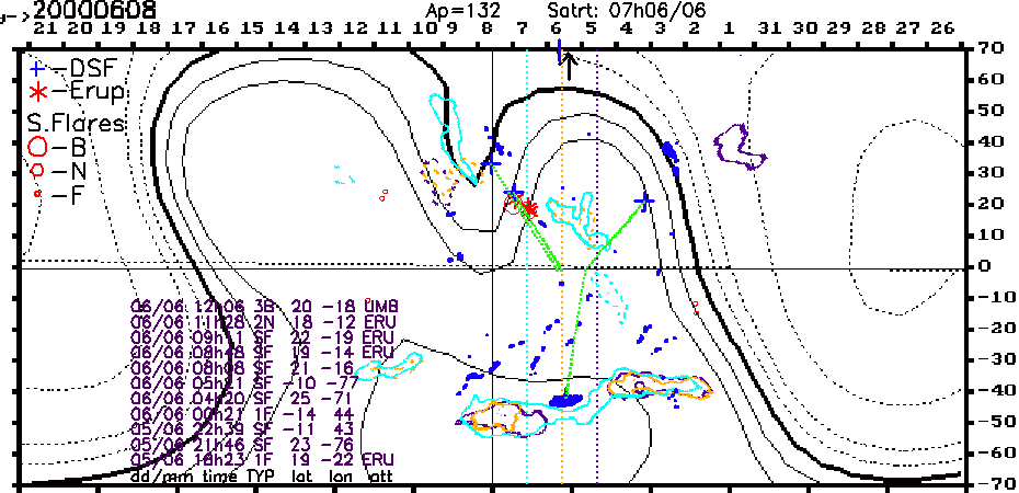
In the upper left corner of the map the date of geomagnetic disturbed day is presented in the YYYYMMDD format. This date coincides with central day of the map marked by solid vertical line (in the present example - 8 June, 2000). Vertical orange, violet and light blue dotted lines correspond to the midday of respectively: the day when the solar wind stream which caused the geomagnetic disturbance started from the Sun, the day before and the day after this day.
Horizontal black solid line is the solar equator. Horizontal dashed line is the Earth orbit projection on the Sun.
The following phenomena are presented on the map: coronal holes, filaments, solar flares and the distribution of the solar magnetic field on the source surface (2.5 solar radii).
The coronal holes are drawn by irregular solid curves with colors according to day of observation (light blue, orange and violet). Such representation permits to show clearly the time evolution of the coronal holes. Initial information about coronal holes locations is obtained from NSO Kitt Peak.
The filaments are indicated by blue spots. The filament data obtained from Paris - Meudon Observatory.
The disappearing filaments are indicated by blue crosses. The green dotted lines connect the positions of disappearing filaments with the Earth projection on the Sun at the moment of the event.
The solar flares are drawn by red circles with radius depending on the H alpha flare brightness: B (Brilliant - largest circles), N (Normal - medium circles) and F (Faint - smallest circles).
Eruptive solar flares are indicated by red stars. The list of the solar flares and their main characteristics is plotted in the bottom left part of the map.
The distribution of the solar magnetic field on the source surface (black solid and dashed curves with different thickness) is used to show the position of the solar magnetic field neutral line (thick solid black line) associated with the heliospheric current sheet (HCS). The initial data is obtained from the Wilcox Solar Observatory photospheric field measurements.
Solar flares, eruptive events and disappearing filaments data are obtained from Solar Event Reports.
Back to the main page